Sunday, February 20, 2011
Where Winter Reigns

Checking the temperature on my truck thermometer for a third time in the past 20 minutes, I once more told myself that the date was February 19th, and not January 19th! Earlier, at 6:00am upon exiting the house, I realized that it was a mite nippy with the temperature stuck at a balmy -24 Celsius! The plus was the fact that the skies were bright and clear in the pre-dawn darkness, and the day promised to be a beautiful time to be out and about in Southern Alberta! I realized that I was running a tad late, as I drove Memorial Drive west, with the full moon visible over the core of the city in the early morning light. Of course, it did not help any that I pulled over and shot the photo above of the downtown looking mighty fine in the -24C early morning light, and then waited for the C train to pass by my location, so that I could add a little motion to my photo.
I soon cleared the west side of the city, and the Rockies were shaping up nice on the western horizon, with their outline sharply defined against the crystal clear skies. The temperature immediately dropped down to -28 Celsius as I drove highway 1 west. The temperatures were not keeping anyone home, as the highway was quit busy with a steady stream of vehicles headed west with skis strapped to their roof-top carriers, headed for the ski-hills of the mountain parks. I would soon leave them behind, or maybe they would leave me behind, as I planned on driving highway 68 once I reached the junction that now loomed on the screen of my Garmin navigator. I actually was headed for Kananaskis Lakes located in Peter Lougheed Provincial Park, however I wanted to get away from the rush of traffic on highway 1 as soon as possible, and Highway 68 provided me with that escape. Once I reached highway 40, I turned south on to the road and proceeded south. The Kananaskis Valley runs North and South, and the valley was still deep in shadows, as the sun, although now above the horizon, had not penetrated the valley floor.
At one point, I recorded my lowest temperature of the morning, that being -30 Celsius! Yikes, I mentally said to myself, glad that I had not found it necessary to be outside my truck for more than a few minutes so far. As I came up through the gap at Galatea, I met a group of about a dozen hikers, who having left their vehicles on the south side of the gap where they had parked, had hiked up the road through the gap, and probably would be headed in to the back country, although I was not sure of their destination, as I was not able to pull up a trail in my head, for the area of Kananaskis they were in. Possibly they were headed up to a frozen waterfall to do some ice climbing, a activity quite popular with climbers in the winter months. Once I reached Mount Lorette Ponds, located just off of highway 40, I pulled my truck over to a stop. The Mount Lorette Ponds are 5 small ponds that were formed by the diversion of the Kananaskis River. They are often stocked with rainbow trout and fishing is permitted, although mainly by the handi-capped, as the ponds are wheelchair accessible in the summer months. In actuality, as pretty as the ponds are in the summer months, I prefer the ponds through the winter months when most everyone stays home, and I have the place to myself. The temperature was hovering at -26 Celsius when I struck out with my camera and tripod. A layer of fresh snow added to the beauty of the ponds, and with the brilliant sunshine it was to die for, I loved it!
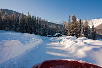
Once I had captured the photos that I couldn't live without, and I had checked out all the fresh animal tracks along the foot-trails, I worked my way back to my truck, and headed further south, stopping briefly at the Fortress Mountain junction service station for a fresh coffee. From there, it was a short run south to the winter gates on highway 40. Here you are forced to either turn around, or as I was doing, drive the road that leads in to the upper and lower Kananaskis Lakes. There is no finer place in Alberta than Kananaskis Country and I find myself exploring the various areas of K Country every chance I can. The fly fishing in its pristine streams and high mountain back-country lakes is superb. For those of you not in the inner circle, Kananaskis Country is the secret playground of the locals, and borders on to Banff National Park, where we allow our visitors to hang out. In 1858 John Palliser a British explorer and his men, crossed through the Kananaskis Pass just a few kilometers to the south in the above photo,
 It was stunningly beautiful, and I could not get enough of of the pristine looking Rockies located in such a beautiful part of southern Alberta. I stopped for photos whenever possible, as there was limited places to stop due to all the snow. Once at the lakes, I got in to my winter gear, and hiked out to the point that over looks Upper Kananaskis Lake. With all the crunchy snow underfoot, and the pristine surroundings that I found myself in, I did not want to go back to my truck. The silence was like a breath of fresh air, which also was in abundance, and I loved my time spent in the Kananaskis Valley on this day.


No comments yet